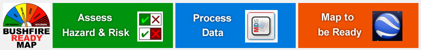
About Bushfire Ready Map
Bushfire Ready Map for iPhone and iPad
available at Apple App Store enables a standardised assessment of bushfire hazard and risk management for homes. The information can be displayed by tap on a home in Google Earth (also available in App Store). Bushfire Ready Map assessments are intended to be conducted by
Bushfire Brigade Officers and the information is to be held confidentially by the relevant Brigade to assist service provision during a bushfire.
The vital information displayed
using the Bushfire Ready Map system assists Brigades contact occupants of homes during bushfire alert and in deployment of resources for fire fighting and evacuation.
The assessment conducted using Bushfire Ready Map during visits by Brigade Officers to homes is also an effective awareness raising process for home occupants and the community.
Bushfire Ready Map has been developed by
CreativityCorp and has been field tested by the
Jardee Bushfire Brigade in Western Australia. Android smartphones can also run Bushfire Ready
Map, see Support below.
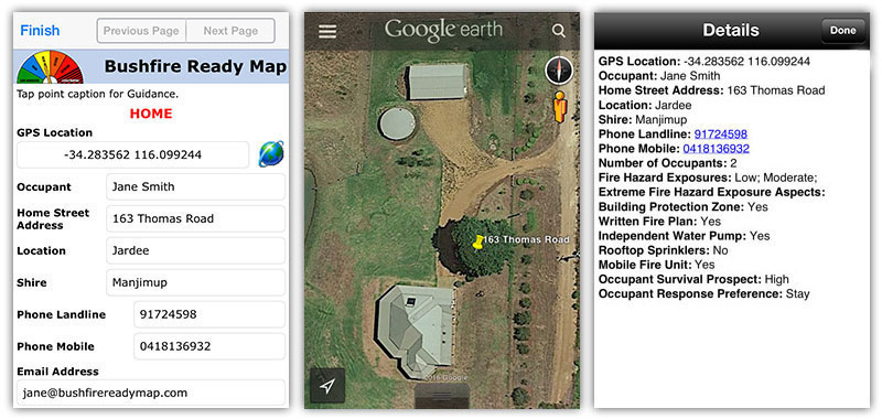
Images from iPhone
showing part of assessment, GPS marker on farmhouse and information display in
Google Earth.
The Bushfire Ready Map system is pitched towards farmhouses and homes on large blocks in rural and outer urban subdivisions.
An Internet connection is not required to conduct
assessments at homes, thus the assessments can be
conducted in remote areas. An Internet connection is
normally required to display the information in Google Earth
either at a fire incident control room or in the field.
However, Google Earth imagery sufficient to cover an area of responsibility of a
local Bushfire Brigade can be
downloaded before
loss of Internet connectivity for subsequent use in the field.
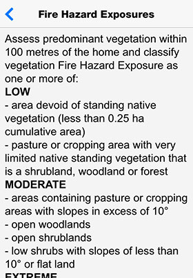
Bushfire Ready Map provides guidance for the assessment process by tap to the assessment point caption. Bushfire Ready Map has been developed using criteria for determining bushfire Hazard Exposure and Building Protection Zone which apply in Western Australia. Similar criteria are used elsewhere in Australia,
and the app guidance can be amended for local criteria.
After conducting assessments of homes using Bushfire Ready Map, connection is made via the mobile phone network or WiFi to
Mobile
Data Studio for processing of data to a KML file
which can be opened in Google Earth. A tap to the GPS
marker on homes displays the vital information. The KML
file can be opened in Google Earth on a smartphone,
tablet, notebook and desktop computer. The data can also
be automatically processed to Excel and HTML in Mobile
Data Studio and downloaded for use by the relevant Brigade.
|
|
The
Bushfire Ready Map 'App' is
available at the
Apple App Store as a free download for installation onto
both iPhone and iPad. Please NOTE
Apple iOS 11 software of November 2017 has disrupted the GPS function for the Bushfire Ready
Map 'App'. Substitute projects are available to overcome this issue, see Support
below.
This does not apply to Apple
devices that are not running software version iOS 11.
Please note that with the iPad for independent GPS
functions, the iPad must be 3G capable. The Bushfire Ready Map app can be
installed to five mobile devices to conduct assessments for a local Brigade area
and the data then be processed in Mobile Data Studio during a 30 day Trial
period. No costs are required to conduct assessments and process data for
Bushfire Ready Map.
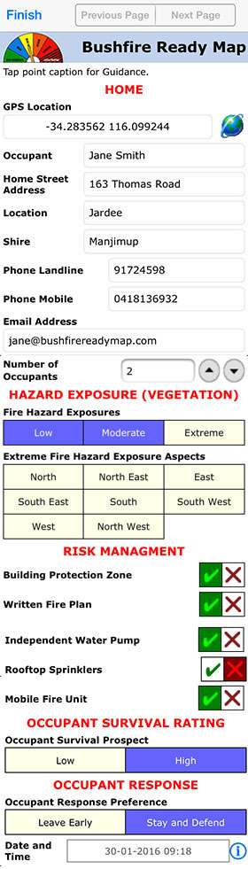
The Bushfire
Ready Map App has one page for assessment listed under 'Projects' and another
page for 'Settings', which will be addressed in the 'Process Data' section below. When the Bushfire Ready Map project is open a simple tap to a data point caption will show 'Guidance' for the point.
Following Guidance is important for consistency of assessments. Please download a copy of full
Bushfire Ready Map Guidance.
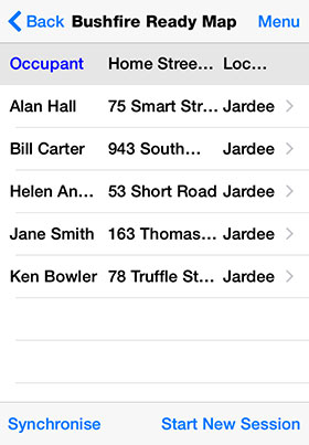
Each completed assessment for a home is called a Session, and
these accumulate in the Session Window before processing of
data. An Internet connection is not required to conduct the Bushfire Ready Map
assessment at farmhouses and other homes.
|
 |
Example of Guidance with project points below.
Finished Sessions save to the
Session Window below.
|
|
|
The assessment data collected in
the Bushfire Ready Map project on the iPhone is sent via
the mobile phone network or WiFi to
Mobile
Data Studio software where it is processed into a
KML file that can be opened in
Google Earth. A 30 day free Trial is provided for Mobile
Data Studio software to enable Bushfire Brigades to process
Bushfire Ready Map assessments for their Brigade area.
It is not necessary to
immediately download Trial Mobile Data Studio software on installation of the Bushfire Ready Map
app to iPhone or iPad. The 30 day Trial software can be
used to process data from up to five mobile devices when
the assessments of homes have been completed. The
Bushfire Ready Map app is matched by a Bushfire Ready
Map project in Mobile Data Studio found on a desktop or
laptop PC in C:\Program Files (x86)\Mobile Data Studio\Examples
The
task of processing Bushfire Ready Map assessment data
can be assigned to a member or associate of the Bushfire
Brigade who is confident with a Windows laptop or
desktop computer guided by the
Mobile Data Studio Skills tutorial. There are two
steps to process the data from the Bushfire Ready Map
app: (1) Sending assessment sessions from mobile devices
to Mobile Data Studio on a Windows laptop or desktop PC,
via either the mobile phone network or WiFi. Here, the
laptop/desktop computer operator will tell the assessors
in the Brigade what Settings should be entered in the
app on the iPhone or iPad to send the sessions. (2)
Processing of the Bushfire Ready Map assessment sessions
from the Database in Mobile Data Studio to a KML file
which can be opened in Google Earth.
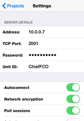
The
Settings page is filled in to
match Mobile Data Studio Set Up.
 |
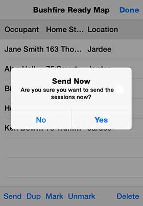
When connection has
been made
Send
sessions.
 |
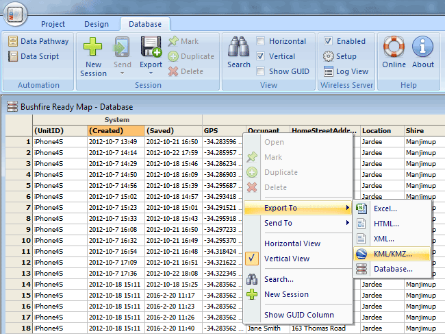
Mobile
Data Studio Database, shown below, collects sessions from the Bushfire
Ready Map assessments, from where the sessions are
processed to a KML file to open in Google Earth. Note
the sessions can also be processed to an Excel spreadsheet for a
convenient summary for the Brigade.
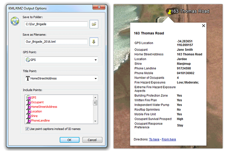
Below are shown typical Options
in Mobile Data Studio for exporting Bushfire Ready Map
assesment sessions to a KML file. Also shown is a
typical outcome for display of the assessment data in
Google Earth on a laptop or desktop PC, smartphone or
tablet.
|
|
|
|
|
|
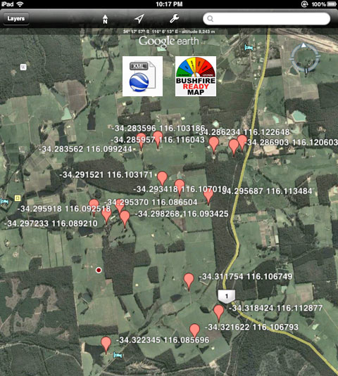
Google
Earth is powerful
free software that is available to download and install
to Smartphones, Tablets, notebook and desktop computers.
A tap on a KML file is sufficient to launch the relevant
map in Google Earth, with valuable information for a
Bushfire Brigade. Please NOTE that while display of KML
files in Google Earth is optimal when a mobile device or
computer is
connected to the Internet,
Google Earth can
operate offline with cached maps. The Bushfire Ready Map shown below is using Google Earth
on an iPad. Please note the standard Bushfire Ready
Map will show yellow GPS pins and
Home Street Address (not shown here for
confidentiality).
The KML data processing system described above can by
selection of which data to show on pins create various
map details in the same overview in Google Earth. For
example an overview of 'Occupant Response
Preference', plus 'Extreme Fire Hazard', plus
'Home Street Address'. Three KML files
would be saved and all three
opened in Google Earth; a tap to the GPS pin would
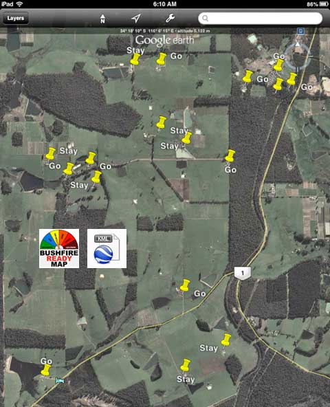
also show full data for each pin. Below is shown
'Response Preference' to either 'Go' early, or 'Stay'
and actively defend.
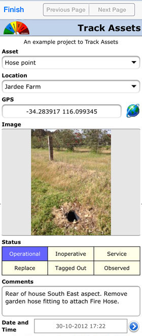
Track Assets
Accompanying the Bushfire Ready Map project is a Track Assets
project that can be useful for managment and tracking of
assets relevant to firefighting. For example, locations
and service status of hydrants, condition of water points in forests,
equipment out of service left in the field for recovery
later; and for tasks such as identifying and locating
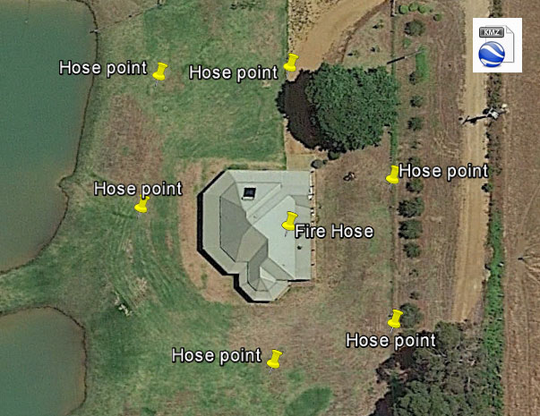
tree branches near power lines. The example below demonstrates location of a fire
hose and hose attachment points around a farmhouse. An
important feature of Track Assets is that it
incorporates a camera image which can be displayed in
Google Earth using a KMZ file which is generated in the same
way as processing sessions to KML files described above.
 |
Track firefighting assets using GPS
plus images for KMZ file.
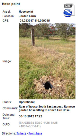
Information box above is
shown in Google Earth by tap on the yellow GPS
and information pins shown in the farmhouse
example below.
Open KMZ files in Google Earth on Windows or Mac
desktop computer. Images in KMZ do not show in
Apple iOS or Android.
|
The Track Assets project can be opened in
Mobile Data Studio and modified to suit the
Brigade's requirements. Feel free to develop more
projects for your Bushfire Brigade. There is no limit to
creativity with Mobile Data Studio.
Support |
Support assistance for the Bushfire Ready Map assessment
project and Mobile Data Studio should be sought from CreativityCorp
by email to
support@mobiledataanywhere.com
and phone 08 97724098.
Please NOTE
Apple iOS 11 software of November 2017 has disrupted
the GPS function
for the Bushfire Ready Map 'App'. Substitute projects
are available to overcome this issue.
Download
Bushfire Ready Map
project and Track Assets project,
open in Mobile Data Studio, and with the iOS 11 iPhone
or iPad connected, via Project > 'Install' upgrade and
replace the projects on the Apple device. Thereafter,
operation of GPS in Bushfire Ready Map and Track Assets
will be restored. This does not apply to Apple devices
that are not running software version iOS 11.
Frequently Asked Questions
Use on Android Smartphones and Tablets?
> Answer:
The Bushfire Ready Map app or project is part of Example
projects in Mobile Data Studio software and can be
deployed to Android mobile devices to conduct
assessments in the same manner as on iPhone and IPad.
See specific
instructions on Mobile Data for Android. The Bushfire Ready
Map project in Mobile Data Studio to install to Android devices is found on a desktop or
laptop PC in C:\Program Files (x86)\Mobile Data Studio\Examples
.
Use on Mobile Devices and Notebook PCs not connected to the Internet?
> Answer:
While display of KML
files in Google Earth is optimal when a mobile device is
connected to the Internet,
Google Earth can
operate offline with cached maps. The map area of
interest should be viewed in Google Earth when connected
to the Internet and it will then be saved for use
offline when there is no connection to the Internet.
Confidentiality of
information collected using Bushfire Ready Map > Answer:
Please see comments on 'Confidentiality
of Data'.
Disclaimer: ‘Bushfire Ready’ and
Bushfire Ready Map
The term
‘Bushfire Ready’ is often used by Governments and others
across Australia to encourage communities to prepare for
bushfires. The term ‘Bushfire Ready’ is used in
Government
programs and
announcements; some examples are in
Western Australia,
South Australia,
Australian Capital Territory and
Tasmania.
Bushfire Ready Map is independent of these and similar
Government programs. Bushfire Ready Map is community
service software made openly available to volunteer
Bushfire Brigades, Country Fire Services and others who
wish to use the software to collect and manage data
relevant to the services they provide. CreativityCorp is not responsible for the data
collected and application of the data.
|
| |
|
|